Source: New
York State Education Magazine, June 1964
The World's Largest Map
-
at the
-
World's Largest Fair
|
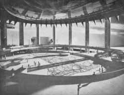
A TRUE SCALE MODEL
of the New York State Pavilion at the World's Fair gives an accurate
impression of how much of the main floor area is covered by the
giant map. The brightly colored road guide is constructed of
polished terrazzo and weighs 114 tons.
|
|
Visitors to the New York State
Pavilion of the World's Fair will be able to make pedestrian
highway tours of the Empire State on a giant (130 feet by 166
feet) terrazzo replica of Texaco's road map.
The main floor of the host State's pavilion shows every major
road, community, river and lake in the same style as the folded
maps that are found in the family car. The familiar red, green
and blue markings are all depicted in perfect scale on a beige
background.
Constructed of 567 gleaming 16-foot squares, the mammoth map
weighs 114 tons and is one of the most extensive terrazzo projects
ever undertaken. According to Rand McNally and Company, it is
the largest known representation of any 50,000 square mile area
of the earth's surface.
THE LONG TASK of designing, building and installing the huge
step-on map began in mid-1963. To provide patterns, sections
of the Texaco map, each measuring 3/4 of an inch square, were
magnified 64 times and electrically projected on 4-foot-square
paper templates tacked to a wall. A team of Yale University Art
School students then traced every map-marking onto the templates.
From these completed templates plywood pattern boxes were
built and taken to a tile factory where the tinted terrazzo mix
of cement and marble chips was poured in. Color pigments were
added to the mixture to depict land areas, rivers and lakes,
and highways. Plastic strips were inlaid to duplicate words and
symbols and, after the mixture had hardened, each panel was mechanically
polished to a mirror finish.
|
|
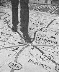
FAR ABOVE Cayuga's waters a
tourist has one foot in the lake without getting the sole of
his shoe wet. World's Fair visitors can walk the length and breadth
of the Empire State in a matter of minutes, selecting the best
routes to take and sights to see.
|
UPON DELIVERY at the New York State Pavilion, the 567 panels
were placed on individual beds of sand and concrete reinforced
with steel mesh. Special suction-cup lifts were used to move
each 400-pound panel into its position in the huge mosaic.
The scale of the map is so large that even local landmarks
could be recognized if they were placed on it.
Children who have read "Gulliver's Travels" may
be reminded of Lilliput. A youngster four feet tall who stands
on the map would find that, according to the map's scale, his
height would be over 50,000 Lilliputian feet.
# # #
|
 |
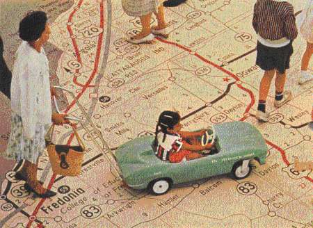
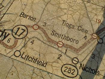
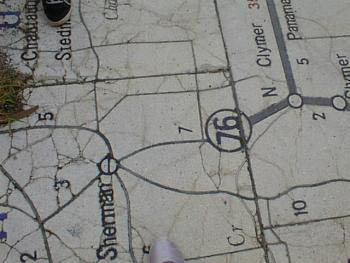
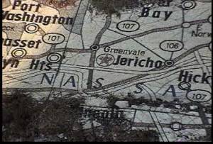
Texaco Road Map of New York Featuring the
NYS Pavilion:
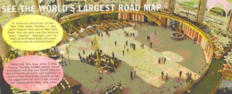
See the World's Largest Road Map
A featured attraction at the
New York State Pavilion is this giant Texaco road map of New
York State. You can walk over the terrazzo map; "explore"
highways and byways of the Empire State. (It's over half the
size of a football field.)
|
Yesterday
Source: Texaco
1965 New York State Roadmap
|
|
Today
Source: © Copyright
2000, BBQ Productions
|
|
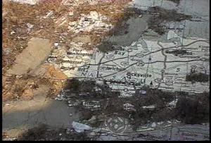
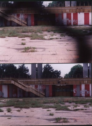
The Texaco map at the NYS Pavilion is not
sinking or ground causing it to crack up. The problem lies on
how the map was installed:
-
Underneath the terrazzo floor
is plywood
-
Underneath the plywood is sand
-
With the floor not properly sealed,
water has gotten underneath it causing the plywood to warp, thereby
making the map crack
The several "concrete patches"
were added throughout the years by the Parks Department (and
others). The terrazzo is about 2 inches thick and is very heavy
to move.
-
Charles Aybar
-
Posting to nywf64.com
Message Board
-
August 7, 2000
|
|

Today
Source: Personal Collection,
Copyright 2000, Rod Smith
|
|
Yesterday
Source: National Geographic
Magazine, April 1965, Vol. 127 No. 4
|
|
Today
Source: Personal Collection,
Copyright 2000, Rod Smith
|
|
(Today
Source: Personal Collection,
Copyright 2000, Rod Smith
|
|
In 1970, the Texaco Map of NY State was
to be removed and restored at the World Trade Center in Manhattan
(the floor rests on sand which is overlaid with plywood). Many
groups opposed this, and the map remained. David Oats himself
launched a campaign to preserve the floor and opposed a roller
rink there. But, Park's Dept. Chief "Heckshaw" wanted
revenue and someone to maintain this building so pushed the roller
rink ahead
-
Charles Aybar
-
Posting to nywf64.com
Message Board
-
July 18, 2000
|
|
Today
Source: Personal Collection,
Copyright 2000, Rod Smith
|
|
Today
Source: Personal Collection,
Copyright 2000, Rod Smith
|
|
Today
Source: Personal Collection,
Copyright 2000, Elizabeth Klug
|
|
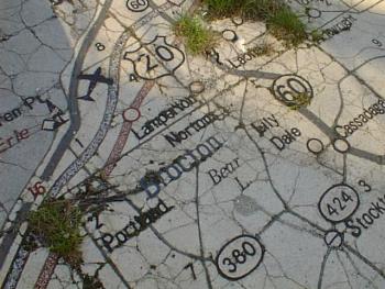
A call today to the "Director of Public
Relations," Mr. John Feeley, at the NYC Park's Dept., Flushing
Meadows Park, confirmed ... that the map has not been removed
at the NYS Pavilion. Mr. Feeley told me that the map has been
vandalized over the years. The map has severely broken up into
small parts and weeds grow throughout it. He also stated that
unless you were looking directly down at the map, it would appear
from the outside view that the map was not there.
-
Charles Aybar
-
Posting to nywf64.com
Message Board
-
June 21, 2000
|
|
Today
Source: © Copyright
2000, BBQ Productions
|
|
|